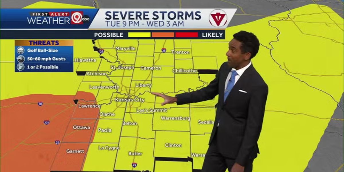
Kansas City’s risk of severe weather from thunderstorms pushing through the area overnight Tuesday has increased, according to the National Weather Service.
The area at an enhanced risk of severe weather has expanded to include the Kansas City metro area and portions of southern Oklahoma, the National Weather Service’s Storm Prediction Center announced on X, formerly Twitter.
Earlier Tuesday, Kansas City was at a slight risk, the second-lowest level, before that risk level was upgraded to enhanced. The Storm Prediction Center uses five categories to describe severe weather risks: marginal, slight, enhanced, moderate, and high. They indicate the increasing likelihood and intensity of severe storms, from isolated and short-lived to widespread and intense.

“Intense thunderstorms, including a few supercells, are possible this evening and overnight from central Kansas and western Missouri into central & southern Oklahoma,” the Storm Prediction Center said. “More isolated storms may develop as far south as central Texas.”
A line of thunderstorms should also develop overnight and pose a threat for severe/damaging winds across eastern Kansas into western Missouri, the Storm Prediction Center said.
The primary threats from the severe weather include hail larger than two inches in diameter, a few tornadoes, and severe wind gusts, the Storm Prediction Center said. Some of the tornadoes could be strong.
Areas to the west and southwest of the Kansas City metro area are at the greatest risk for a strong tornado. Areas just west of the immediate metro area are also at a greater risk of seeing hail greater than two inches in diameter.

The Kansas City and St. Joseph areas are also included in an area where there is a 10% or greater chance of wind gusts exceeding 74 mph.
In response to a question on Facebook Tuesday morning about the timing of the storm in the metro area, the National Weather Service in Kansas City said there may be a few supercells ahead of the main line of the storm.
“The best chance for those to develop looks to be southwest of the Metro; however, if they can hold together, we could see some severe storms capable of large hail and an isolated tornado as early as 9 p.m.,” the weather service said.
Otherwise, the line of storms appears to be the leading player and is expected to reach the Kansas City metro between 1 and 2 a.m., the weather service said.
Weather watches and warnings
A live data feed from the National Weather Service containing official weather warnings, watches, and advisory statements. Tap warning areas for more details. Sources: NOAA, National Weather Service, NOAA GeoPlatform and Esri.