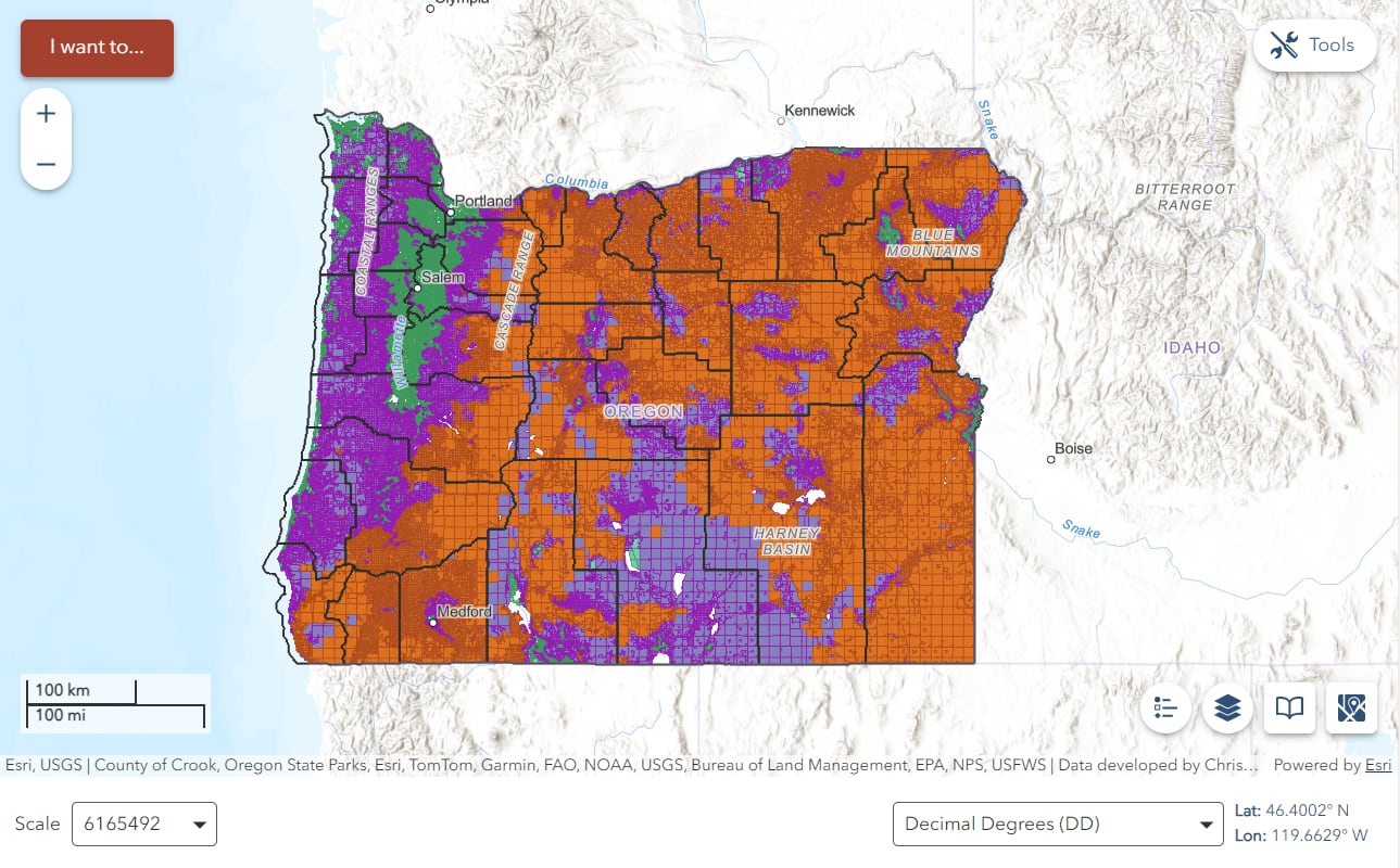
PORTLAND, ORE. (AP) — According to new wildfire hazard maps released Tuesday, residents in Oregon who reside in specific high-risk wildfire regions designated by the state are now required to adhere to new building rules and decrease the amount of vegetation surrounding their homes.
The maps were made public in the wake of last year’s record-breaking wildfire season and the 2020 firestorms that destroyed thousands of houses and claimed nine lives.
Oregon law establishes new regulations for residents of the most fire-prone areas that also border wildlands, such as woods or grasslands, based on state-developed maps that will not have an impact on homeowners insurance rates. Six percent of the state’s approximately 1.9 million tax lots are affected by the rules, which is less than the previous version created in 2022 but withdrawn after residents expressed fears that it would hike insurance rates.
Climate change is causing wildfire seasons to lengthen and intensify, and Oregon is not alone in struggling to control the danger. A new law issued last week in California will compel insurance companies to offer coverage in high-risk wildfire zones in order to continue doing business in the state. Colorado and Washington state have also recently taken action to address fire danger in their towns.
Only roughly 106,000 tax lots in Oregon will be impacted by the new development and so-called defensible space requirements. However, as the state continues to face record-breaking wildfires, experts believe it’s a critical step in identifying and protecting regions that are prone to fire.
In regions that were previously believed to be nearly fireproof due to a wetter, cooler environment, residences on the Oregon coast, just inland from the Pacific Ocean, have even been destroyed by fires since 2020.
Andy McEvoy, a faculty research assistant at Oregon State University’s College of Forestry who worked on the map, told The Associated Press that beyond 2020, it is no longer possible to claim that this is a problem that only affects central and southwest Oregon. All of those incidents made the need for a really statewide approach to wildfire risk response very clear.
Among the biggest natural disasters in the state’s history, wind-fueled fires over Labor Day weekend in 2020 destroyed thousands of homes and other structures, burned over 1,875 square miles (4,860 square kilometers), and claimed nine lives.
Additionally, the wildfire season of 2024 was historic. It burned a record of almost 3,000 square miles (7,770 square kilometers), mostly on range and grazing area in the rural east of the state, and cost Oregon more than $350 million, making it the most costly event in the state’s history.
According to McEvoy, officials will use the maps to help towns that are most in need of wildfire supplies. A home can be made more fire-resistant by removing vegetation to establish a defensible space buffer zone and adding fire-resistant elements like fiber cement cladding or metal roofs.
According to him, we may improve the chances of a structure lasting by managing our vegetation in a particular way and using specific materials when building it. However, we won’t alter the likelihood that the fire will start in the first place.
The Oregon Department of Forestry released two maps created by experts at Oregon State University that depict the wildland-urban interface and the levels of wildfire hazard.
A 2023 state law prohibits insurers from raising prices or canceling homeowner insurance policies based on a wildfire hazard map created by a state agency. McEvoy did point out that the majority of insurers had long been creating their own estimates of wildfire risk.
According to him, there isn’t anything on this map that hasn’t been depicted or portrayed in earlier publications created by scholars or the insurance industry.
The initial wildfire hazard maps were altered by Oregon fire officials and researchers following thousands of public comments and state-wide public hearings. Reducing the hazard status of irrigated farming, hay, and grazing lands was one of the main modifications, according to McEvoy. The latter are frequently grazed for a large portion of the fire season and watered during haying, which lessens the amount of vegetative fuels on the landscape.
Wildfire hazard maps have been in place for years in California, Arizona, and New Mexico. A statewide wildfire risk map was mandated by Washington state lawmakers this year, while Colorado established a wildfire resiliency code board in 2023.
Only until the wildfire danger map appeals period is finished will the Office of the State Fire Marshal, which will oversee the defensible space codes, and the Building Codes Division, which will oversee the building codes, start the adoption process. Landowners of impacted tax lots will get notifications from the Oregon Department of Forestry.
— The Associate Press’s Claire Rush
This article was written by Associated Press journalists Sejal Govindarao in Phoenix and Susan Montoya Bryan in Albuquerque, New Mexico.
Note: Every piece of content is rigorously reviewed by our team of experienced writers and editors to ensure its accuracy. Our writers use credible sources and adhere to strict fact-checking protocols to verify all claims and data before publication. If an error is identified, we promptly correct it and strive for transparency in all updates, feel free to reach out to us via email. We appreciate your trust and support!


