Spring showers are nothing new for Ohio residents, but the latest forecast from the National Weather Service suggests there’s a bit more than the usual drizzle on the horizon.
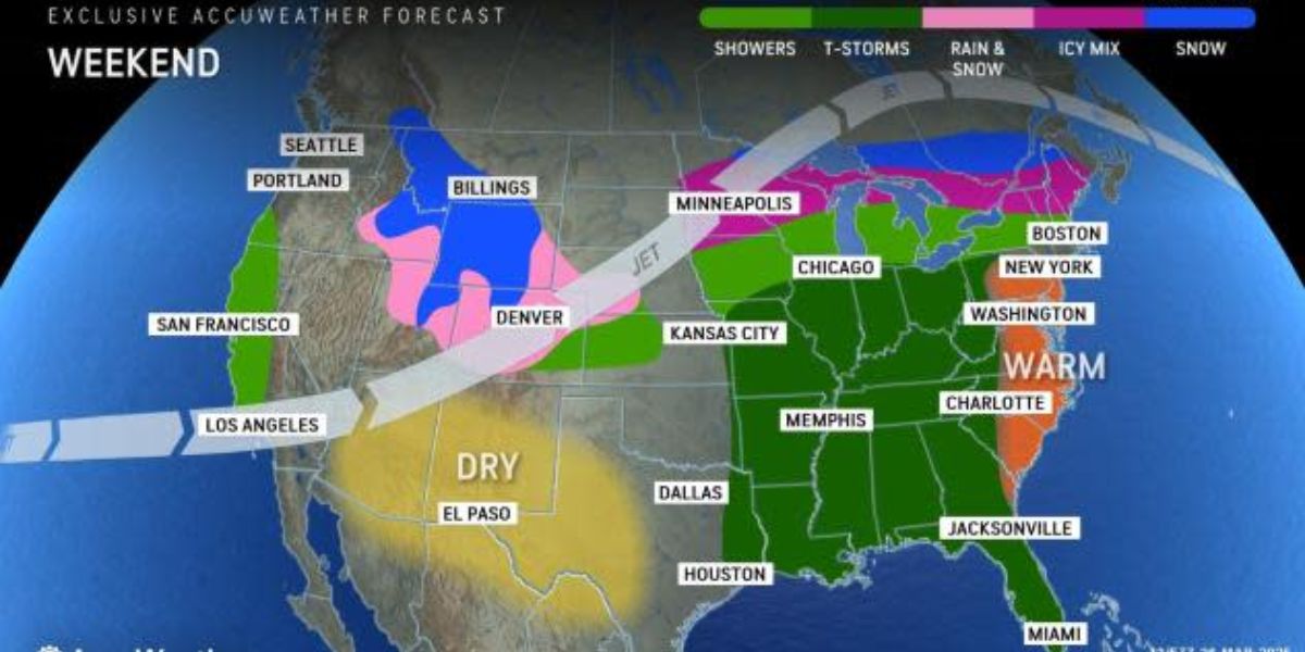
As per the NWS update, today, we may see some wet weather courtesy of a “weak system,” which brings with it a chance for showers across parts of Columbus, Cincinnati, Wilmington, and other regions. The real head-turner comes later this week when a warmer front pivots north, increasing the likelihood of showers and thunderstorms from Thursday into Friday.
The patchy presence of fog was the main concern early this morning, particularly across areas of eastern/southeastern Indiana and southwestern Ohio.
An SPS, or Special Weather Statement, was issued for these localized dense fog events outside of river valleys. Some improvement was anticipated around sunrise, aligning with the increase of mid-level clouds. This was set against a backdrop of temperatures hovering near or slightly below the norm for this time of year in Ohio, as reported by the NWS.
As we head into Thursday, we’re looking at a region still grappling with the influence of northwesterly flows at upper levels and conditions ripe for cyclogenesis on the lee side of the Rocky Mountains. All this meteorological jargon translates to an increased chance for rain come Thursday afternoon, particularly across eastern Indiana and southwest Ohio, making for a potentially soggy day in those areas.
Update: Cold weather advisory for Oregon until Thursday morning
Thanks to the aforementioned warm front, temperatures are set to swing upwards into notably warmer territory. This ushers in a moist air mass from the Gulf, causing temperatures to soar above average for Ohioans. A succession of weather systems will then descend upon the region, with showers expected to pepper Cincinnati and Columbus through the weekend. The weekend will culminate with a potentially thunderous Sunday as a cold front cuts through the state. This latest peek at the weather forecast was given a spotlight in the NWS’s Area Forecast Discussion.
The skies over regional airports may witness fluctuating visibility over the next few days. Morning fog should dissipate before transitions to a southerly flow and subsequent rain chances by mid-morning Thursday. Aviation stakeholders should keep an eye out for MVFR, or Marginal Visual Flight Rules conditions, which are potential from Thursday night all the way through Sunday, indicating that the less-than-ideal weather may impact air travel.
Safe to say, for aerial and ground-level plans alike, Ohioans should stay tuned to updates and prepare for a wet start this coming weekend.